 Moderate

 Moderate
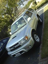
It was raining in the valleys, but crossing the Cajon Pass on I-15 put me under bright blue skies. Turning east on highway 173 off of I-15, I planned on checking out Silverwood lake and visiting Pilot Rock, but the road was closed. So I continued on 173 and hit dirt after only a few miles (I'd never been on a dirt highway before). I turned off on Willow Creek Jeep Trail and Pinncales Staging Area. I continued to straddle the cloud line, at times in foggy and wet conditions and other times in the sun (in other words, half the time wishing I still had the open top Jeep, and half the time happy I was warm and dry). Stopped for lunch, and to let Reilly stretch, in the Stove Flats area, then went down Rouse Ranch Trail. Both trails were moderately difficult, fun, and scenic. Next in line was Dishpan Springs Trail, described as one of the most difficult in the San Bernardinos. I decided that might be a little too much for my first trip with the 4Runner and headed down to Lake Arrowhead instead. It was all paved highway from there (where the 4Runner definitely beats the Jeep).
This was only a day trip and with the skipped trails, I was actually home a little early. But it was enough to give me the confidence that the 4Runner could handle just about anything the Jeep could. I'm looking forward to spring!

